

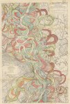
Harold Fisk’s 1944 alluvial maps of the Lower Mississippi River Valley for the Army Corps of Engineers. There were 15 giant plates in total, tracing the meanders and oxbow bends of the Mississippi back hundreds of years.
These are beautiful and rare. After failing to find an original on ebay or anywhere, I ended up downloading a hi-res copy off US military site, printing in full size and framing, and now we have it at home, though sadly we never found a place to hang it on the wall.
